
The 5 Best Hikes Near NYC (According to Locals)
You may not think of New York City as an epicenter of outdoor adventure with hiking trails galore. But while the city itself might be more of a concrete jungle than an actual jungle, head just a bit outside the city and you’ll find rolling hills, river canyons, cool small towns, and an abundance of hiking trails. Of course, when we say these are the best hikes near NYC, well, the word “near” is relative. But all of these are within an easy train ride from Manhattan within two hours or so of the city. All so you can enjoy an adventurous day trip without too much hassle.
Want to go further afield? We recommend trekking a few hours to Lake Placid, especially if you enjoy some winter fun.
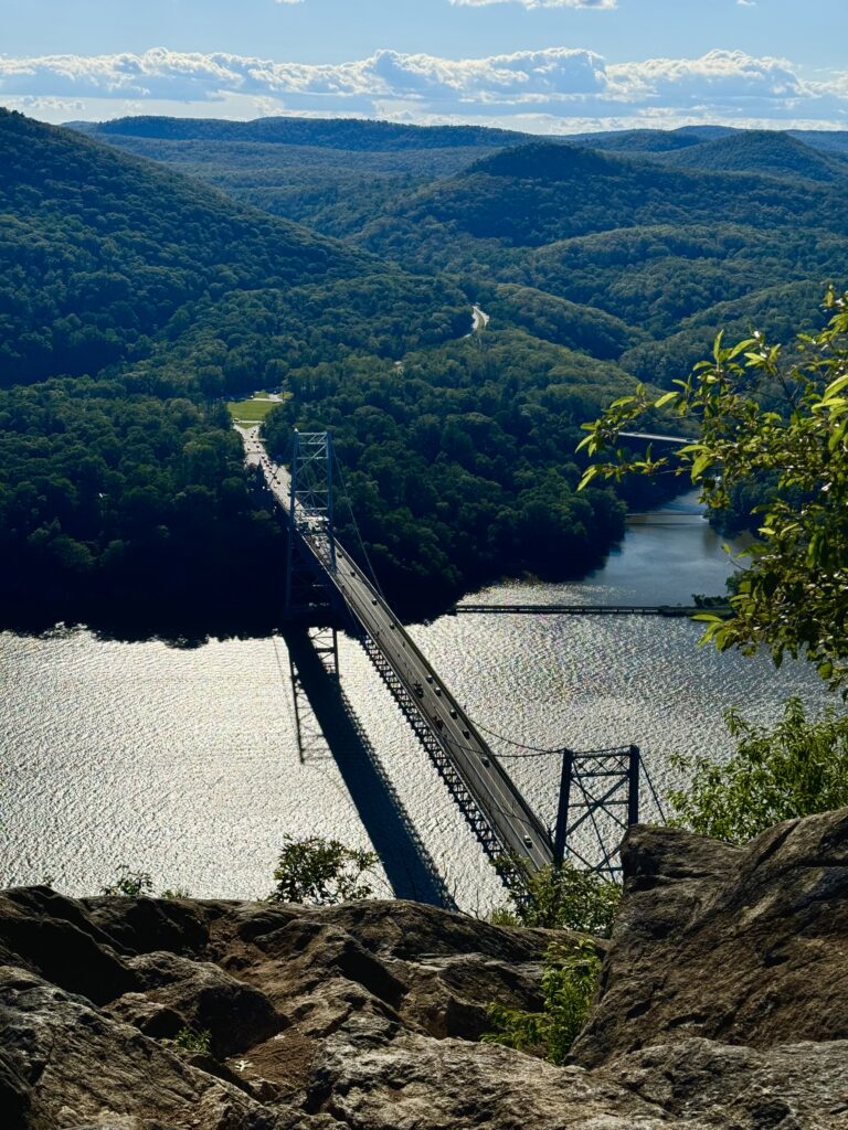
Anthony’s Nose: 2 miles, out-and-back
Patrick Nugent is a photographer in NYC who has lived in the Lower Hudson Valley for 14 years and hikes or MTB in the area nearly every weekend.
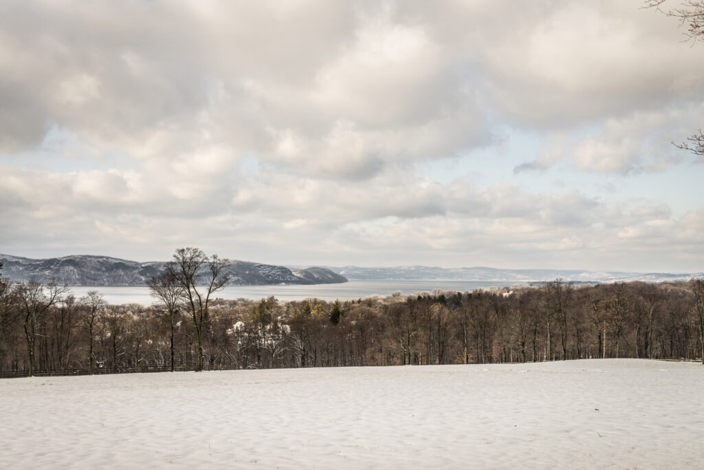
“Anthony’s Nose is a great year round hike just 50 miles north of NYC. A quick 60-minute train ride to Peekskill from Grand Central on the Metro North will put you close to the base of the hike. From there you can get to one of the best views the region has to offer with the Bear Mountain Bridge below you and Bear Mountain and the lower Catskill Mountains across the river into the distance.
“While the trail is definitely a bit more technical than some might expect, it’s also not the most difficult; I have seen many kids (mine included) do the hike in Crocs. After the hike and on your way back to the Peekskill Metro North station I would also recommend heading to the Copperhead Club for a snack and a drink.”
Tip: Pack microspikes in the winter when snow and ice can make trails slippery.
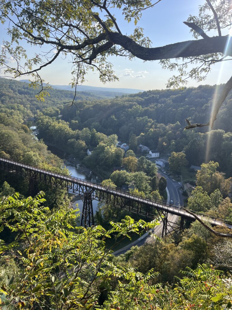
Joppenbergh Mountain Loop: 1.5-2 miles, loop
Amanda Wiley was born and raised in Queens, NY, has thru-hiked the Appalachian Trail (and others), and now lives in the Hudson Valley. Support local art and find out more about Wiley’s Zine Machine project here.
“Two hikes that kept my heart on trail while nesting in my apartment were the Joppenbergh Mountain Loop and the Empire State Rail Trail (below). In Rosendale, the Joppenbergh mountain is right behind Main Street with parking available in the municipal lot. There’s a map at the start that describes a few different routes. I like to follow the path on the left. This path goes steadily uphill with a classic New York State rock scramble about 1 mile in. I get to the cliff above the treeline with the first clear view of the trestle, have my summit snack, and turn around at about 1.2 -1.5 miles to enjoy the downhill descent. This makes for a nice day hike for any paced hiker, taking anywhere from 1-3 hrs, with a round trip totaling about 2.4- 3 miles. This area allows for about 7 miles of trails depending on your route choices.
“From New York City, you can travel to Rosendale using the Trailways bus service out of Port Authority [about a 2-hour trip]. The Rosendale bus stop will leave you right in front of TRT bike shop 0.2 miles from Stewarts. Make a left from there on to Main Street, and a right at the Library. Walk past the library on Central Ave. On your left hand side you will see a metal gate that leads to a spur trail that takes you all the way to the municipal lot where the Joppenbergh Mountain Loop trailhead is.”
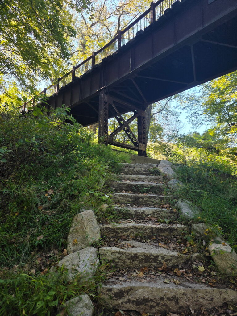
Wallkill Valley Rail Trail: 1-13 miles, out-and-back or point-to-point
Amanda Wiley was born and raised in Queens, NY, has thru-hiked the Appalachian Trail (and others), and now lives in the Hudson Valley. Support local art and find out more about Wiley’s Zine Machine project here.
To make the trip worth the travel time, just down the road from the Joppenbergh Mountain Loop is another enjoyable trail. “The Empire State Rail Trail is a 750-mile foot, bike, and equestrian path that connects towns throughout New York State. The path that connects the town of Rosendale to New Paltz is generally quite flat and smooth and takes up 6 of the 13-mile section known as the Wallkill Valley Rail Trail. There are portions that are paved and some that have dirt and rock foundations with a few wooden and metal bridges along the way.
“Mile markers, signs and pamphlets can be found along the route, and my favorite surprise of all-the Rail Trail Cafe (open March-October), located on unceded land of the Esopus Munsee people. It’s a nice spot to take a break, have lunch and fuel up for the rest of the hike. They host events and other art installations there as well. Across the trail from the cafe there is a grass field available for camping.
“There’s plenty more to explore about Rosendale including its roots as the land of the Lenape people, colonization leading to the limestone excavation and mining industry, and the foundation the cement provided for landmarks across the United States, including the base of the Statue of Liberty, the Brooklyn Bridge, NYS thruway and so much more.”
Swan Lake Loop, Rockefeller State Park Preserve: 1.4+ miles, loop
Robin Helman is a Westchester County resident, travel writer and founder of Go Love NY, dedicated to exploring New York State and highlighting escapes from New York City. She frequently hikes throughout Westchester and the Hudson Valley and shares guides to local towns, culture and outdoor experiences.
“Rockefeller State Park Preserve offers one of the most peaceful hiking experiences just north of New York City. The Swan Lake Loop is an easy-to-moderate trail that follows historic crushed-stone carriage roads laid out by the Rockefeller family, winding through hardwood forests, open meadows, and along the edge of scenic Swan Lake. Along the route, hikers cross picturesque stone bridges and pass quiet streams and wetlands that attract a wide variety of birds and wildlife. The well-maintained paths and rolling terrain make it a relaxing walk with plenty of beautiful Hudson Valley scenery.
“Take Metro-North’s Hudson Line from Grand Central Terminal to Tarrytown (about 40 minutes). From the station, the Preserve’s main entrance is about a 10–12 minute Uber or taxi ride away.” Many more miles of looping and connected trails offer the opportunity to extend your hike as far as your feet can carry you.
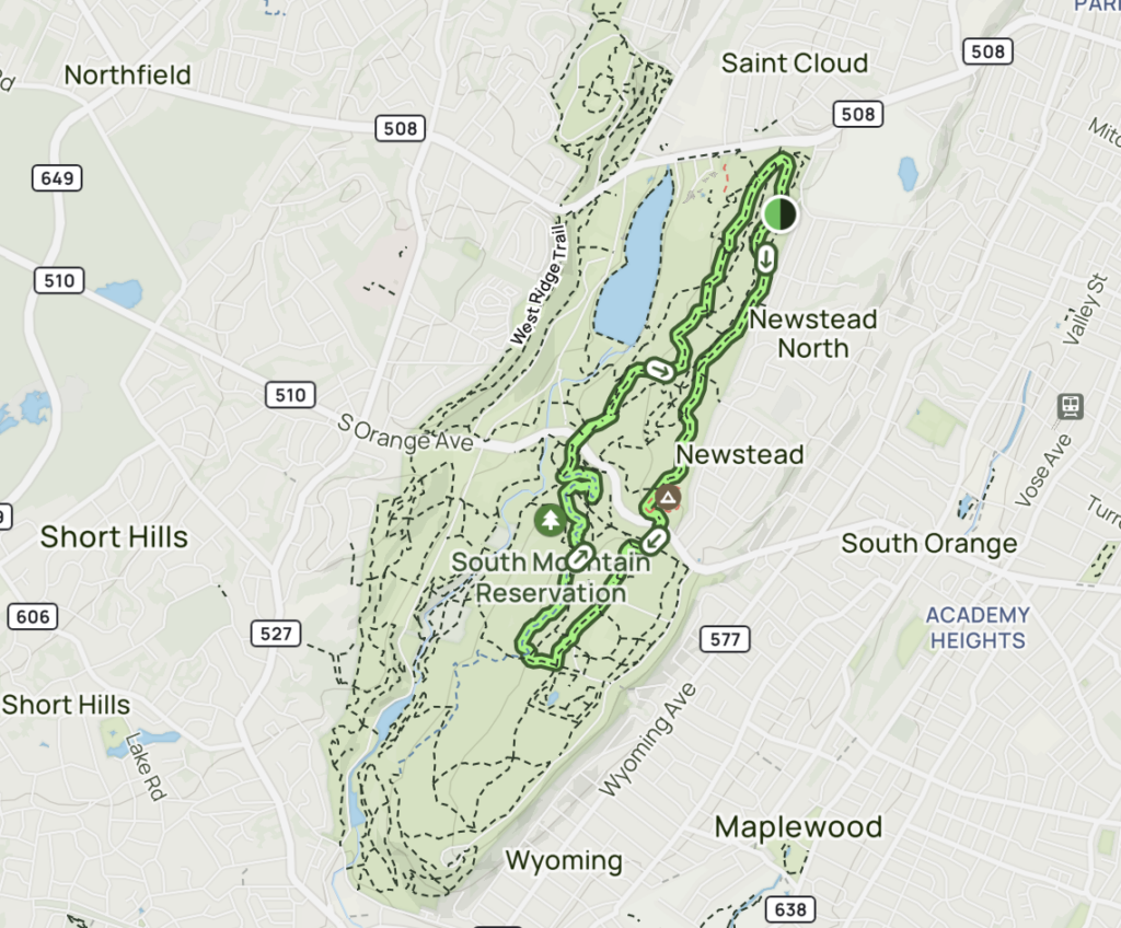
Turtle Back Loop and Hemlock Falls Trail: 6 miles, loop
Dovi Geretz, Chief Technology Officer at SlickTrip (a real-time flight price alert platform), used to live in NYC and enjoyed taking a break from the city to explore surrounding hiking trails.
“I loved escaping to South Mountain Reservation nature reserve in West Orange, New Jersey, whenever I needed a break from the fast pace of the city. My favorite hiking trail in the reserve is Turtle Back Loop and Hemlock Falls. With an elevation gain of about 574 feet, it’s a moderate trail that rewards hikers with peaceful sounds of waterfalls, plenty of tree cover, lush greenery, and so many pretty views. There are some rocky portions of the trail that have tree roots, so I recommend wearing hiking boots.
“It’s also easy to get to this reserve from Manhattan via public bus, and takes about 1.5 hours each way. From Port Authority Bus Terminal, take a NJ Transit bus toward West Orange (check current routes) then you can walk the final 1-2 miles to Turtle Back Loop / Hemlock Falls trail. You can also take an Uber from the bus station in West Orange if you want, but I always enjoyed the pre-walk to my hike.”
Bottom Line
While hikes in NYC itself might be limited, there’s plenty to explore within a an hour or two train ride. So as long as you plan ahead, miles of hiking trails can be yours without much hassle. Looking for a convenient place to stay in NYC? Check out Staypinapple. It’s conveniently located, but not very sustainable, so take that into consideration. Then spend some time breathing some fresh air in nature the next time you’re in the city and wander on.


![The 5 Best Barefoot, Wide Toe Box Hiking Shoes for Men So You Can Stop Abusing Your Toes [2026]](https://terradrift.com/wp-content/uploads/2026/06/DSCF0338-768x512.jpg)