
The 5 Best Hikes in Sedona, Arizona (According to Local Experts)

Sedona is a stunning hiking destination. I’ve been several times, including on a group hiking trip and am mesmerized every time I step foot on trail. The red dirt, massive canyons, towering rock features, it’s an outdoor playground like no other. But with miles and miles of interconnected trails to choose from in and around the city, how are you supposed to know which are the best hikes in Sedona? Especially if you have limited time to explore.
Fortunately, not only do we have personal experience with hiking in Sedona and surrounding (sprawling) Coconino National Forest, we know plenty of other folks who know far more about the area than we do (you know, people who live and work there). So we asked them to share the best Sedona hikes so you can explore the best of the best.
Stay on Trail
When in Sedona, or during research before your trip, you may see recommendations for hiking trails to caves. Skip these. Most are not maintained by the Forest Service or local trail organizations and lead to places still sacred to the local Yavapai-Apache Nation. Hiking these trails is both irresponsible and inconsiderate.
The 5 Best Hikes in Sedona

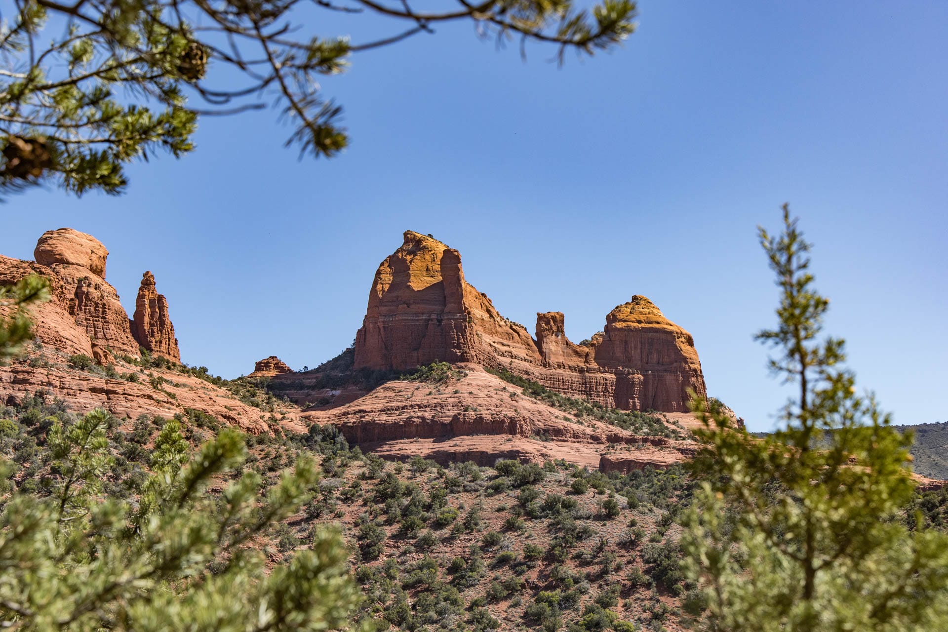
Bell Rock and Courthouse Butte Trail: 0.8 – 2.8 miles, out-and-back or loop
Bruce Leadbetter, Founder of 360 Adventures, an Arizona guide and travel planning service, is an Arizona native who has been visiting Sedona since the 1970s and been a professional guide in the area since 1992.
“The Bell Rock system is a beginner-friendly set of trails, and some even opt to climb up Bell Rock. This is the perfect family/beginner hiking area. The trails are well marked and you can get into ‘nowhere’ pretty quickly & safely. The Courthouse Butte hike, which is part of the Bell Rock system, takes you into a remote area of Sedona. It’s in a Wilderness area so there aren’t (shouldn’t be) any mountain bikers. Also, the red rock cliffs in the distance are the perfect rock formation area (think cloud shapes in the form of recognizable things).
“You can adjust hike length by taking a shorter, more direct route, making it a loop or starting at Bell Rock Vista Trailhead.”

Cathedral Rock Trail: 1.1 miles, out-and-back
Bri Crowder, an Arizona native and travel advisor with Boutique Travel Advisors, has spent her life hiking and exploring the area.
“It is so hard for me to narrow down my favorite hikes. Sedona is known for its stunning red rock formations and beautiful hiking trails that offer breathtaking views of the surrounding landscape. This is a challenging hike that rewards you with stunning views of Cathedral Rock and the surrounding area. The trail is steep and rocky, but the views are well worth the effort.”
You can extend your hike by starting at other trailheads, including Yavapai Vista or Baldwins Crossing. Visit at sunset for even more magical views (just don’t forget your headlamp).
“No matter which hike you choose, be sure to bring plenty of water, wear comfortable shoes, and be prepared for the weather. Sedona can get hot during the summer months, so it’s important to stay hydrated and protect yourself from the sun.”

Munds Wagon Trail to Merry Go Round Rock: 6.5 miles, out-and-back
I hiked this one myself last time I was in Sedona and loved it. And not just because there were almost no other people on it. The dusty trail leads you past overlooks, through juniper, past big views of rock formations, and along some of the more well-regarded vortex activity in the area (if you go in for that sort of thing).
It ends at a wide, red slick rock plateau with a massive rock wall on one side where you’re treated to excellent views of the whole area. There aren’t a lot of steep ups and downs, but between the sun exposure, rocky paths and length it can be moderately challenging. It’s one of the few trailheads you can park at any day of the week.

West Fork of Oak Creek Trail: 1-6.5 miles, out-and-back
David Stephan is an Arizona resident who publishes TrailKiosk, a site that shares updates and news about Arizona trails.
“This local classic is actually in the town of Oak Creek Canyon just on the north side of the Sedona strip. This one is very reminiscent of parts of Zion National Park–like a mini Narrows. The trail follows a river, which has carved out a canyon over time that has very cool red rock overhang. You’ve got a mix of pines and deciduous trees that turn to classic autumn colors in November, a few river and stream crossings, and a large trailhead with parking lot, restrooms and informational signage at the trail kiosk.
“It’s an out and back, so you can turn around whenever you like and outside of the sometimes slippery water crossings, it’s an easy hike with very little up or down to worry about. This is one I love to take my young kids to and just let them run wild.”

Chicken Point via Little Horse Trail: 4 miles, out-and-back
Matt Caracciolo is a writer and editor with Shaka Guide, which offers self-guided driving and walking tours around the U.S. He researched, wrote, and tested the driving tour of Sedona and has hiked several trails in the process.
“This is an easy to moderate hike with some uphill as you climb to Chicken Point, a lesser-known but no less stunning vantage point amidst the red rock cliffs. I felt like I had stumbled onto a special place, as some jeeps from backcountry tours were parked near the overlook, and I had merely hiked there.
“I actually reached Chicken Point via the Chapel Trail, which leaves from the parking lot for the Chapel of the Holy Cross. They discourage parking in their lot solely for the trail, so make sure you also visit the chapel (which has a fantastic view and is a great way to start the hike). Otherwise, you can access Chicken Point via the Little Horse Trail, which is a bit longer, and has limited parking. Fortunately, the trailhead is one of the stops on the free Sedona Shuttle.” Sky Rock Hotel
Sedona Trailhead Transportation + Parking Tips
While trailheads abound in Sedona and just about all trails connect at some point, the city is compact and trailhead parking is limited. Plan to use Sedona’s free and easy Trailhead Shuttle system or hourly hop-on, hop-off Verde Shuttle instead of driving, which is required on some days as several parking lots are closed on certain days of the week.

Where to Stay: Sky Rock Hotel
There may be no more magical and comfortable place to bed down for the night in Sedona than at the Sky Rock Hotel. With extended balconies with comfy seating and fire pits, it’s the best place to enjoy the view as the sun rises or sets and comfortable, natural rooms seem nestled comfortably in the hillside itself.

Bottom Line
Sedona isn’t just a fun place to search for vortexes and stock up on crystals; it’s surrounded by tons of easily accessible outdoor recreation opportunities for folks who love to hike. So pack plenty of water and explore these local favorite trails in Sedona. They’re guaranteed to impress. Don’t forget plenty of water!